Very Poor - complete lack of any warmth with only one day attaining 20°c - marginally colder than average with rainfall close to average.
After July became the first month of 2017 to finish colder than average, August has now followed suit and it really was a poor month to end a poor summer.
The final figures for August may show that it was only marginally colder than average and with rainfall near to average, but the reality was much grimmer, best demonstrated by one simple fact: only one day in the month actually managed to attain 20°c - there wasn't even two good days to rub together!
The mean maximum temperature was therefore down on average and if it hadn't been for a run of very mild nights from the 22nd, the final mean temperature would have been much worse and indeed those eight mild nights (22nd-29th) managed to push the mean minimum temperature slightly above average.
The majority of the month's rain fell before the 20th when it then became light and patchy, but there would be no recovery to better weather and indeed the close of the month saw a return to cooler conditions.
Thunder was heard on one day, 31st, but without any storm to accompany it and otherwise it was a quiet month.
MSLP of 1013.1 Mb was -1.0 Mb below the local average for August with low pressure systems a regular feature on that westerly flow and although high pressure was often nearby, it never became established.
Overall a mean minimum of 10.35°c and a mean maximum of 17.77°c saw the temperature 0.5°c below the 1981-2010 average and it was the coldest since 2014. The highest maximum temperature recorded was 22.2°c (22nd), the lowest minimum 4.4°c (13th).
Rainfall of 68.7 mm (Crosby Ravensworth School 73.6 mm - Castlehowe Scar 95.7 mm - Reagill ??? mm) made it the driest August since 2010 (2 having been drier and 8 having been wetter of the 11 now recorded) and was 60.7% of average for 2007-16.
Locally, rainfall percentages were generally just either side of average, the east of the county tending to fall just below average, but with the Lake District seeing above average rainfall.
At the Met' Office site at Newton Rigg, 85.4 mm (121.8%) made it the driest August since 2013 and in a series back to 1900 there has been 68 drier and 48 wetter (1yr of missing data). In a series back to 1951 a mean temperature of 13.85°c is the coldest since 2014 with 23 having been colder and 43 warmer.
Figures from the Environment Agency’s rainfall sites were, (figure in brackets being the monthly average for 1961-90) ‘Data kindly provided by the Hydrometry and Telemetry team of the Environment Agency (Penrith)’:
Kirkby Thore 62.2 mm (68.5 mm)
Haresceugh Castle (Kirkoswald) 86.75 mm (99.2 mm)
Brothers Water 225.98 mm (198 mm) and
368.8 mm at Seathwaite Farm (Borrowdale - 240 mm [average for 1981-2010])
SUMMER
Here at Maulds Meaburn, summer 2017 with 332.2 mm of rain (Crosby Ravensworth 348.8 mm) has been the wettest since 2012 and of the eleven now recorded, 7 have been drier and 3 have been wetter. That 332.2 mm represented 112.9% of the rainfall for those previous ten summers.
A mean temperature of 14.16°c is the coldest since 2015 and of the nine summers now recorded, four have been warmer and four colder. That 14.16°c makes the summer of 2017 some 0.1°c warmer than the average of those previous eight.
It is somewhat depressing to realise that only twelve days during the three months of summer attained 20°c, with just ten managing the old standard of 70°f (21.1°c).
At Newton Rigg rainfall totalled 303.6 mm and had a mean temperature of 13.9°c. In comparison to the 1981-2010 averages this represented 152.6% of summer rainfall and it was 0.3°c colder than average.
In a series back to 1900 (3 years of incomplete data), this was the 12th wettest and in a complete series back to 1957, 30 have been warmer, 28 have been colder, with 2 having the same mean temperature.
August
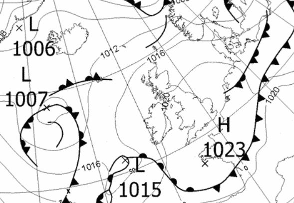
1st - 8th The month opened with a continuation of the westerly flow and low pressure (LP) to the fore that had affected much of July's weather. This brought a generally unsettled and cool picture, but inbetween any frontal systems we still managed to see a decent amount of sunshine.
The LP system that brought an unsettled end to July hung about for one further day, bringing a few showers and this was then followed by two further LP systems that saw the unsettled theme continue upto the 8th.
The LP that arrived on the 2nd would stay with us through to the 4th during which time it was a little bit of most things, even some sunshine. Rain was at its heaviest in the early hours of the 3rd and yet the 4-5th which saw us inbetween any fronts, remained dry with sunny intervals.
Ahead of the next area of LP there was a brisk W'ly wind over the top of high pressure (HP) that sat in the Atlantic, with the new LP arriving on the 6th. This brought rain for a few hours in the afternoon, but yet again we still saw some sunny spells along with the odd spell of rain over the next few days.
Temperatures during the period were depressed and mainly below average. The day-time maximum fell as low as 15.5°c (6th) and was no higher than the 18.7°c of the 2nd and indeed fell away after the 3rd. Under clearer skies overnight 4-5th, the 5th started with a low of 5.1°c.
9th - 10th The HP out in the Atlantic then nosed in over the UK and whilst an improvement on what had gone before, it still failed to hit the heights of summer, mainly due to its position as it drew in a cooler NNW'ly on its eastern flank.
The days were dry and saw some sunshine, but variable amounts of cloud were a slight nuisance. Both days attained 19°c, the 10th the warmer at 19.2°c.
11th - 12th LP then returned, tracking well north of the UK, but its trailing fronts shunted the HP away and brought a couple of dreary days.
The 11th was a day of drizzle and light rain, totalling 1.9 mm with a further 5.1 mm on the 12th before the associated fronts cleared east allowing the HP to ridge back in.
13th HP then very briefly ridged over the UK, for a day, giving one decent day. With clear skies first thing, the temperature dropped away to a month's low of 4.4°c (39.9°f) in the early hours, but the day did see some good sunny spells. However, a WNW'ly breeze ensured that the maximum temperature only peaked at a low below average 17.7°c.
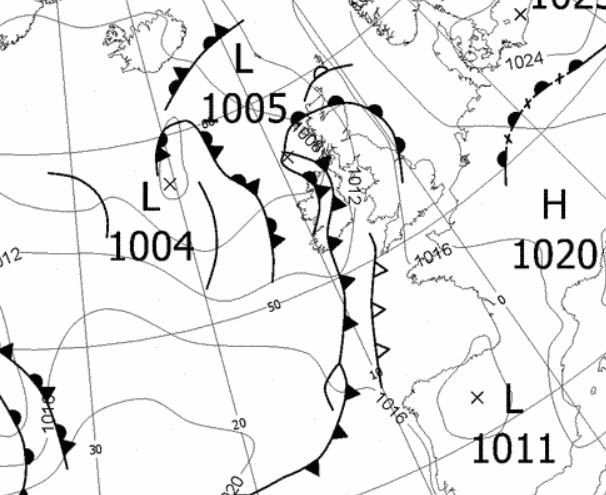
14th - 20th Apart from brief ridges of HP on the 16th and 20th, the period was under the influence of LP systems that brought spells of rain, including the month's wettest day on the 14th.
Whilst the 14th was the month's wettest day, 10.4 mm is not that much and some of this also fell overnight into the 15th, which saw a gradual improvement to sunny spells once the fronts cleared east and HP started to ridge in. After a reasonable day on the 16th, the next area of LP arrived during the evening and overnight into the 17th, giving 8.0 mm of rain. Then behind those fronts the 17th became a reasonable with sunny spells, in which the temperature rose to 19.7°c.
That area of LP had become semi static near Faroe during the period and this saw frequent showers on the 18th, some of which were quite heavy. Less showers on the 19th but it remained cloudy all day and both these two days had seen the temperature become quite cool, hovering just either side of 16°c.
The ridge of HP on the 20th was weak and fleeting, but it did at least allow for some sunny spells.
21st - 23rd As such LP was the dominant feature for the period, however, HP was close by on the near continent and which contributed to a warmer phase. The month's warmest day fell during the period, but now the mild nights became quite notable and which resulted in 'rescuing' the mean temperature which upto this point was running about 1°c below average.
LP in the Atlantic pushed a pair of fronts (a weak upper occlusion followed by a warm front) slowly north over the UK and which introduced a mild S-SE'ly. This brought a spell of rain during the evening of the 21st and with those fronts slow to clear on the 22nd, the day whilst the month's warmest at 22.2°c (72°f), had a muggy feel about it - this would be the only day in August to see 20°c and we had had a 28 day wait since the 25th July since the last occasion!
The overnight minimum temperatures though were high. The 22nd only fell to 14.9°c, but the 23rd at 15.8°c (60.4°f) was the year's highest minimum and the cause of an uncomfortable night's sleep.
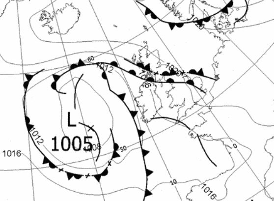 0600 Hrs 22nd - low pressure and fronts bringing the warm but muggy conditions
24th - 31st Through to the month's end HP did try to gain a foothold, but failed as LP was always nearby. However, it did become drier with no meaningful rainfall during the period.
Apart from the last two days of the month the nights remained very mild, but despite sunny spells, the 29th only recorded a month's lowest maximum of 14.4°c due to a cold front introducing fresher air from the Atlantic and which saw the end of those mild nights.
The month ended with a little distant thunder in the afternoon and some showers, but the height and speed of the river suggested that the thunderstorm was relatively near.

Rainfall totalled 68.7 mm for the month, with rain recorded on 20 days of which 14 were 'Wet days' (1.0mm +).
The Mean Temperature for the month was 14.06°c -- The Mean Max' was 17.77°c -- The Mean Min' 10.35°c.
We had 0 Air Frosts in the month (year 32) -- Grass frosts totalled 0 (year 67).
The 1 foot soil temp ranged from a low of 14.8°c on the 7th + 14th and 21st to a high of 16.1°c on the 23-24th -- with a monthly mean of 15.4°c
The 1 meter soil temp ranged from a low of 13.7°c on the 12-16th to a high of 14.1°c on the 25th and 30-31st -- with a monthly mean of 13.9°c
COMPARISONS:-
* August 2017 rainfall was 60.7% of the average for 2007 - 2016
* August 2017 was 0.16°c colder than the average for 2009 - 2016 and 0.5°c colder than the local long term average 1981-2010
* This makes the Jan' to August period of 2017 some 0.76°c warmer than the average for 2009-16 and with 85.2% of average rainfall for 2008-16
JANUARY 2010
FEBRUARY 2010
MARCH 2010
APRIL 2010
MAY 2010
JUNE 2010
JULY 2010
AUGUST 2010
SEPTEMBER 2010
OCTOBER 2010
NOVEMBER 2010
DECEMBER 2010
JANUARY 2011
FEBRUARY 2011
MARCH 2011
APRIL 2011
MAY 2011
JUNE 2011
JULY 2011
AUGUST 2011
SEPTEMBER 2011
OCTOBER 2011
NOVEMBER 2011
DECEMBER 2011
JANUARY 2012
FEBRUARY 2012
MARCH 2012
APRIL 2012
MAY 2012
JUNE 2012
JULY 2012
AUGUST 2012
SEPTEMBER 2012
OCTOBER 2012
NOVEMBER 2012
DECEMBER 2012
SUMMER 2012
REVIEW OF 2012
JANUARY 2013
FEBRUARY 2013
MARCH 2013
APRIL 2013
MAY 2013
JUNE 2013
JULY 2013
AUGUST 2013
SEPTEMBER 2013
OCTOBER 2013
NOVEMBER 2013
DECEMBER 2013
REVIEW OF 2013
JANUARY 2014
FEBRUARY 2014
MARCH 2014
APRIL 2014
MAY 2014
JUNE 2014
JULY 2014
AUGUST 2014
SEPTEMBER 2014
OCTOBER 2014
NOVEMBER 2014
DECEMBER 2014
WINTER 2014
REVIEW OF 2014
JANUARY 2015
FEBRUARY 2015
MARCH 2015
APRIL 2015
MAY 2015
JUNE 2015
JULY 2015
AUGUST 2015
SEPTEMBER 2015
OCTOBER 2015
NOVEMBER 2015
DECEMBER 2015
REVIEW OF 2015
JANUARY 2016
FEBRUARY 2016
MARCH 2016
APRIL 2016
MAY 2016
JUNE 2016
JULY 2016
AUGUST 2016
SEPTEMBER 2016
OCTOBER 2016
NOVEMBER 2016
DECEMBER 2016
REVIEW OF 2016
JANUARY 2017
FEBRUARY 2017
MARCH 2017
APRIL 2017
MAY 2017
JUNE 2017
JULY 2017
OTHER ARTICLES
The Oldest Inhabitant
An Inch Of Scotch Mist
© Darren Rogers 2010-17
Want to comment on this site? email